Well, technically we’re at the Seno Ultimo Esperanza (Last Hope Sound), which connects with the Pacific about 50 miles away through coastal islands, but for me that’s close enough.
We left Torres del Paine National Park around noon today, after driving to a vantage spot on the east side to view the rock towers between the other mountain peaks. It was a sunny day, finally, and we lucked out with a great view of Torres del Paine, along with a waterfall at our feet and a herd of guanoconos grazing around us.
The route out of Torres del Paine to Puerto Natales is richly visual: the milky-blue glacial lakes in the park, the brown desert around Cerro Castillo, the wide farm valleys undergoing autumn harvest by gauchos as we approached Puerto Natales, and then the islands and ocean waterways at the port. Everywhere mountains, mountains, mountains. Those coastal islands? All snow capped mountains.
We hit pavement – actual poured concrete, not just asphalt -- south of Cerro Castillo, the first paved road we’ve seen for days.
We stopped in Puerto Natales to fuel up – things were getting a little dicey in that department, but we still haven’t had to use the spare 5 gallon can – as well as to get groceries. We were able to see a little of the small working port town while finding a gas station and supermercado.
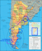
Puerto Natales is in the second to bottom circle in the map on the blog site. We're amping beside the road tonight on Chile’s Ruta 9 about an hour south of Puerto Natales.


No comments:
Post a Comment