The Trip

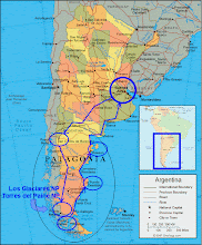
In April of 2009, my wife Bobbie and I did a road trip across Patagonia in a pickup truck camper; driving down the Andes on Argentina’s western highway Ruta 40, coming back east along the Straits of Magellan in Chile, and then back up Argentina’s Atlantic Coast highway Ruta 3. We camped along the way in national parks, municipal campgrounds, truck stops, and many times just alongside the road; and we stopped at every place possible, both famous and not. You can see our route of travel here.

This travel blog is a daily journal of the trip, along with a few pictures (see
http://parkenbi.zenfolio.com/patagonia for more photos). The "Last Entry" below is the trip summary, but our journey actually began at a train station in Florida so you'll want to start there ... go to "We're Off".

Wednesday, April 29, 2009

Day 28 – Reality Check

Laguna Lobos to Buenos Aires

THE FINAL SUPRISE of the day occurred when we arrived at the Buenos Aires Airport, as everyone there – passengers, ticketing agents, and security – was wearing hygiene facial masks; a very odd sight to unexpectedly see, and causing both of us to feel unprotected and maybe just a little amused. Further, as we walked in we were handed official cards advising against traveling to Mexico or to the United States due to the Swine Flu outbreak “unless absolutely necessary” … it was like those advisories one hears about that warn against traveling to some third-world country. We hadn’t kept up with the news too well while traveling, but we got a quick education on the potential epidemic this evening, as well as a different perspective of the U.S.

The first surprise of the day was driving the camper in the large city of Buenos Aires to return it to the rental depot, as there was heavy traffic unlike our initial experience a month back. Bobbie was both patient and tolerant with all my swearing and poor shifting, and we eventually made it to the depot with the camper undented and all skin intact.

The best surprise of the day was that my Buenos Aires friend Kary and her family were also very tolerant with our traffic issues, waiting extremely patiently to pick us up when we were finished with the camper and then provided a wonderful dinner, listened to our Patagonia stories, and delivered us to the airport for the flight home. We are very fortunate to have experienced such great hospitality and warmth from Kary and her family … as well as everyone else in all of Argentina.

Tuesday, April 28, 2009

Day 27 – Gauchito Gil

TODAY WAS JUST a drive day and not very interesting; Bobbie and Bill just grinding out the miles on Ruta 3 to get a camping spot on the outskirts of Buenos Aires.

So instead, here is the explanation for the “Mystery of the Very Red Doghouses” roadside shrines that we saw starting on our second day in Argentina … and on every day since.

Thanks go to Kary in Buenos Aires for sending me the following:


EL GAUCHITO GIL

The Gauchito Gil is a legendary character of Argentina's popular culture. His full name was Antonio Mamerto Gil Núñez and he was allegedly born in the area of Pay Ubre, nowadays Mercedes, Corrientes, possibly in the 1840s, and died on 8 January 1878.

Popular accounts vary, but in broad terms the legend tells that Antonio Gil was a farm worker and that a wealthy widow fell in love, or had an affair, with him. When her brothers and the head of the police (who was also in love with the widow) found out about their relationship, accused him of robbery and tried to kill him. He enlisted in the army to escape from them. In the army, he fought against the Paraguayan army. Finally, he could come back to his village as a hero. But, when he arrived at his village, he was forced to return to the army to fight in the Argentine Civil War. It was a brother versus brother war and "Gauchito" Gil was tired of fighting. Therefore, he decided to desert.

In the end the policemen caught him in the forest. They tortured him and hung him from his feet on an Algarrobo tree. When a policeman was going to kill him, Gauchito Gil said to him: "Your son is very ill. If you pray and beg me to save your child, I promise you that he will live. If not, he will die". Then the policeman killed Gauchito Gil by cutting his throat. That was January 8th, 1878.

When the policemen came back to his village, the one who had killed Gauchito Gil learnt that his child was in fact very ill. Very frightened, the policeman prayed to "Gauchito" Gil for his son. And afterwards, his son got better. Legend has it that Gauchito Gil had healed his murderer's son. Very grateful, the policeman gave Gil's body a proper burial, and built a tiny shrine for Gauchito. Moreover, he tried to let everybody know about the miracle.

Gauchito Gil is thought to be a saint for many people of the provinces of Formosa, Corrientes, Chaco, the north of Santa Fe and even the province of Buenos Aires. One can spot smaller shrines of Gauchito Gil on roadsides throughout Argentina. Great pilgrimages are organized to the sanctuary (located about 8 km from the city of Mercedes) to ask to the saint for favors. Moreover, each January 8th (date of Gil's death), there is a celebration honoring Gauchito Gil. There, the people dance, sing and drink, and also play folkloric sports as tanning horses, bulls and others animals. The Catholic Church hasn't declared Gauchito Gil a saint, but many Argentine people are promoting him.

Monday, April 27, 2009

Day 26 – The Parrots of El Condor

(click to enlarge)

JUST OUTSIDE the coastal pueblo of El Condor, a very sheer cliff parallels the road for many miles; take two steps out of your car and you can spit over the edge 200 feet down to a flat beach, a quarter mile wide at low tide.

But it was what was living on the cliff wall that was so interesting: thousands and thousands of colorful, screaming parrots. At the time of day we were there – 9 AM – they were leaving the cliff and flying up over the edge, maybe circling around us as we stood on the top, and then headed inland. Later we found a way down to the beach and walk along the bottom of the cliff, apparently greatly annoying the parrots as they screamed and flew around us at our every move.


After watching the parrots for an hour, we drove and drove, shooting for a coastal campsite on the far side of Bahia Blanca, But it was not to be, as the police had stopped road access to the camping area – apparently for construction – and we ended up staying at a nice pasada – a hotel – along Ruta 3 near Coronel Dorrego.

Sunday, April 26, 2009

Day 25 – One Last Day in Patagonia

Peninsula Valdes to El Condor


WE TURNED OFF of Ruta 3 onto a coastal ripio road today, as a way to stretch out Patagonia. The coastal route was fascinating; passing by very poor rancheros, a salt marsh full of flamingos, and ocean cliffs dropping to rocky beaches. We are camping tonight in the town of El Condor at the mouth of the Rio Negro -- the campground gates are open, there is electricity, but no one is here, and so far we haven’t paid anything. The bathrooms are locked so we’ll have to find other solutions in that department.

Early tomorrow we will cross the Rio Negro, and in so doing we will officially leave Patagonia. It is still about 800 miles to Buenos Aires, but we will cross that distance in a different frame of mind.

Umm … did you get the sunset symbolism?

Wild boar skins on the fence of a ranchero

Saturday, April 25, 2009

Day 24 – Península Valdés

Peninsula Valdes is located in the map on the blog site in the upper right blue circle within the Patagonia area (the one with “Rawson” in the circle).


WE'RE SPENDING a couple of days out on the Valdes Peninsula, having driven about 30 miles across an isthmus to a huge landmass surrounded by the Atlantic, and surprise … what’s out here is flat arid Patagonian steppe, roads of ripio, sheep estancias, herds of guanacos, and tropical storm force winds. The desert goes right to the ocean’s edge, which Florida-boy Bill can’t quite handle.

The peninsula is a nature preserve, and on that ocean edge are packs of sea lions and elephant seals. Did you know they hung out together? I didn’t -- lions and elephants don’t exactly pal around in Africa, don’t these guys follow the same rules? Anyway, we drove around most of the Peninsula today, stopping here and there to check out the beach or the view. There is an odd-looking roadrunner type bird here that has the suicidal trait of running directly towards our truck as we approach, making driving interesting.


We’re camping in the same place tonight, Piramedes Beach, again to ourselves. The wind is smashing the waves into the rock platform on which we’re camping, causing huge sprays … very exciting to watch … hope the tide doesn’t get too high tonight…

Friday, April 24, 2009

Day 23 – Too Much Excitement

Camarones to Peninsula Valdes

Back on Ruta 3 heading north again, think it’s starting to get to us: the perfectly straight road, mirror flat landscape … blah, blah, blah. Here’s a typical conversation while we’re grinding out the miles –

Bobbie: “You know, some of the bushes are taller than the ones we saw yesterday, definitely higher than my ankles.”

Bill: “Yeah, and they also seem greener than what we were seeing yesterday.”

Bobbie: “Maybe, kinda hard to … OH MY GOD, IS THAT A TREE?”

Bill (in shock): “IT IS! IT’S A TREE! HOLY COW!”

We get a grip on ourselves and keep driving. Ninety minutes of silence passes.

Bobbie: “You know, I think some of the bushes might be half way up our shins now.”


The big excitement of the day occurred when we ran low on fuel and we finally had to use our spare 5 gallons that we’ve been toting around for three and a half weeks. Of course, we ran into the lone gas station on this stretch five minutes later, but I don’t care … got to use the spare fuel!


We are now camping on the Valdes Peninsula Nature Preserve, located in the upper right blue circle within the Patagonia area (the one with “Rawson” in the circle) on the blog site map. We are on a beach – actually next to the cliffs on a rocky platform with the ocean tides creeping up over the edge– and have the area to ourselves. There was free camping in the nearby pueblo of Puerto Pyramides, but it was a little crowded there as the electricity was also free and half the town had moved into the campground.

We had a new category in the spillage department today, when the wind blew the camper door back on Bobbie as she was stepping out to dump some excess chicken soup. The heater for the camper is in that door and caught most of the soup. We’re not looking forward to firing that thing up.

Thursday, April 23, 2009

Day 22 – Penguins!

Caleta Olivia to Camarones

WE HEARD SEVERAL TIMES since being here that all penguins leave Argentina by the end of March, going out to sea or to Brazil and not returning until September; and so we weren’t expecting to see any, but today at Cabo Dos Bahia Nature Preserve there they were!

Earlier, we had decided to escape from Ruta 3’s forever flatness by detouring 40 miles to Camarones – which turned out to be a very pleasant small coastal town, so pleasant that we’re camping there tonight – and from Camarones we took a ripio road about 20 miles south to see the nature preserve, hoping to see more sea lions. The sea lions were there, many more than we saw yesterday but much further away, however the path to the beach went right through a colony of Magellan Penguins! They are mostly interested in each other or in keeping an eye on the sea gulls overhead; and just stood in place looking at us as we walked by. We stayed until the sun went down.


Camarones

Wednesday, April 22, 2009

Day 21 – Along the Atlantic

Puerto San Julian to Caleta Olivia


RUTA 3 is a long stretch from San Julian to Caleta Olivia … fuel up before you go. We drove on flat treeless Patagonian steppe, the road typically arrow-straight to the horizon. The Atlantic was a few miles off to our right, but about 1000 feet lower than the steppe, where the landscape abruptly descended via cliffs down to ocean waves crashing on rocks.

We took a detour out of Puerto San Julian to see the cliffs, and spent an hour watching a pack of sea lions on those rocks, highly cool. This seldom-used scenic route wasn’t in our guide book, but it should be ... maybe we should write our own.


There was a honkin’ cross wind this afternoon while driving on two-lane Ruta 3 on that treeless steppe, and we experienced a shock wave with every oncoming truck. The camper would suddenly pull hard directly toward the passing vehicle, we’d hear a boom that sounded like a cannon being fired into a wind tunnel, and our heads would snap to the right as the top of the camper was yanked to the left. This only occurred with a strong cross wind -- nothing like it with either a head or tail wind – and the phenomenon was very encouraging to the driver to keep both hands on the wheel.


Now camping in a private campground outside of Caleta Olivia. The temperature dropped after a front passed through today, and it will be a cold night.

Tuesday, April 21, 2009

Day 20 – Ruta 3

Rio Gallegos to Puerto San Julian (Argentina)


WE ARE HEADING north along the Atlantic coast on Nacional Ruta 3, which will be our home for about 1600 miles until we reach Buenos Aires; and also which we understand is paved the whole way. This is a housekeeping and travel day: got the laundry done, washed two week’s worth of Ruta 40's dirt off the truck, saw the town museum; and then hit the road on a dreary day.

While heading up Ruta 3 we decided to drive into Monte León National Park, which was an old huge sheep estancia between the Atlantic Ocean and the highway and is now Argentina’s newest national park. And there, on a dirt road far from anywhere we again ran into Simon and Katherine; last seen many days ago at Torres del Paine. I now have no choice but to conclude that we are the only four people traveling across Patagonia.

Park Ranger, orphan guanoco, and Bobbie at the Monte Leon National Park Visitor Center

Monday, April 20, 2009

Day 19 – Back in Argentina

Chile’s Pali-Aike National Park to Rio Gallegos, Argentina

WHEN WE ARRIVED in the big frontier city of Rio Gallegos today, we found out there is no camping in the town or anywhere near, so we were forced – forced, I tell you – to stay at a nice hotel downtown. What a luxury: modern plumbing, warmth, a regular bed. And also, as it would have been ever so crass to sit outside the hotel in the camper and eat as the evening shoppers walked by, we had no choice but to have dinner at an elegant restaurant, at 7 PM, which is normal to us but Argentineans don’t eat until much later, so we had the fancy restaurant to ourselves.

Earlier today we woke to a clear but cold morning in Chile’s Pali-Aike National Park, and hiked to one of the nearby volcano cones before leaving. There are only five things in this park, but each is in abundance: high treeless Patagonian steppe, dormant ancient volcanoes, piles of lava, guanacos, and wind.

Bobbie is a little frustrated with constantly losing fresh produce to the food police, and she developed a plan to avoid having our groceries confiscated for when we crossed the border from Chile into Argentina today: she was going to confess to having a few apples and then give them up as a decoy. However, her plan was thwarted when the border guards failed to do any inspection whatsoever and we sailed into Argentina with all food in place. What has become of our world when the police are not consistent? Is all sanity lost?

Sunday, April 19, 2009

Day 18 – At the End of the World, Almost.

Puerto Natales to Pali-Aike National Park (Chile) While driving along the Straits of Magellan today … boy, I sure dropped that in real casual, didn’t I? I gotta write it again: WE DROVE ALONG THE FRIGGIN’ STRAITS OF MAGELLAN TODAY! We could see Terra del Fuego! Places I studied in grade school, but never dreamed I’d see! I stuck my hands in the freezing-ass cold waters of the Straits!! OK, anyway, while driving along the straits we stopped at a huge, virtually abandoned sheep estancia (San Gregorio) that was right on the straits, and that at one time must have been the biggest, richest operation in the Magellan area. One empty creepy building after another; glass broken, paint peeling, Spanish graffiti on the walls, ancient litter on the floor. Except … it wasn’t quite dead. Nobody else around, but there were fairly recent sheep skins hanging on the fences, a few sheep in the pastures, and some of the sheep skulls lying around weren’t quite clean, if you get my drift.

Estancia San Gregorio (More pictures here)

We went to the ferry crossing for Terra del Fuego, with the far shore only 2 miles away. We thought about taking the ferry over, but it would have been for bragging rights only: “We drove to the end of the world”; and so we turned and headed north, towards Argentina. With that turn, we are psychologically homeward bound, headed back towards Buenos Aires and the United States. We are now camped at Chile’s Pali-Aike National Park, which is located near the border with Argentina and is all about the small volcano peaks in the area. The campground is in a circular area surrounded by high walls of volcano debris, to protect the campers from the strong winds here on the high Patagonian steppe. We think it will be a very cold night. Tomorrow we will hike on short trails to see the insides of the inactive cones. It was not easy to get here – middle of nowhere feeling again -- and we are the only visitors to the park today. We are in the bottom circle on the map on the blog site.

Saturday, April 18, 2009

Day 17 – At the Pacific!

Torres del Paine to Puerto Natales (Chile)


Well, technically we’re at the Seno Ultimo Esperanza (Last Hope Sound), which connects with the Pacific about 50 miles away through coastal islands, but for me that’s close enough.

We left Torres del Paine National Park around noon today, after driving to a vantage spot on the east side to view the rock towers between the other mountain peaks. It was a sunny day, finally, and we lucked out with a great view of Torres del Paine, along with a waterfall at our feet and a herd of guanoconos grazing around us.

The route out of Torres del Paine to Puerto Natales is richly visual: the milky-blue glacial lakes in the park, the brown desert around Cerro Castillo, the wide farm valleys undergoing autumn harvest by gauchos as we approached Puerto Natales, and then the islands and ocean waterways at the port. Everywhere mountains, mountains, mountains. Those coastal islands? All snow capped mountains.

We hit pavement – actual poured concrete, not just asphalt -- south of Cerro Castillo, the first paved road we’ve seen for days.

We stopped in Puerto Natales to fuel up – things were getting a little dicey in that department, but we still haven’t had to use the spare 5 gallon can – as well as to get groceries. We were able to see a little of the small working port town while finding a gas station and supermercado.

Puerto Natales' waterfront

Puerto Natales is in the second to bottom circle in the map on the blog site. We're amping beside the road tonight on Chile’s Ruta 9 about an hour south of Puerto Natales.

Friday, April 17, 2009

Day 16 – Torres del Paine National Park II

AT ONE SPOT WHILE DRIVING around the park today we had one of those 360° panoramic views of the mountains and glacial lakes, and Bobbie said “From here you can see every kind of weather!”

It was true: you could see it snowing on some mountains, but others had sun. Some of the lakes had whitecaps from the strong wind, while others were calm. The clouds were hanging low and foggy in some places and other areas had blue sky. Of course, it was raining where we were.

Because of the wild weather we decided not to do the nature thing today, and instead go see the two impressive hotels located within the raw vastness of the park. We had lunch at the older resort, which is located on an island in one of the lakes and is accessed by a pedestrian bridge. The other is a new, very high-end, architecturally-elite, adventure hotel that you have to be Bill Gates to afford.

Here’s pics –


We ran into Simon and Katherine -- fellow travelers from Australia -- again when they pulled into the same campground we’re in. From here we’re off on separate paths and it’s very unlikely we’ll bump into them again, so we had a last big chat and took each other’s pictures.

Thursday, April 16, 2009

Day 15 – Torres del Paine National Park

We poked around the park today --- here are a few photos:


Staying at Lago Pehoe campground in the NP. We’re on the Pacific side of the Andes, and it is warmer, wetter, and greener here. Because of the wetness there are flying insects – the first we’ve seen in Patagonia –one of which is nasty little biting black fly. The weather is much more variable here than on the eastern dry side of the mountains.

It is weird using Chilean Pesos, as everything is in thousands – the campground costs 8,000 Pesos per night, but in US Dollar that works out to $14.50.

Wednesday, April 15, 2009

Day 14 – In Chile

El Calafate to Torres del Paine National Park, Chile


Pavement. Ripio. Pavement. Ripio. Ripio. Ripio. Mind-numbing flatness, the horizon a pure line. Breathtaking sweeping grand vistas of mountains and mesas and canyons. Sunny. Overcast. Cold. Cool. Windy. Calm. Guanacos. Guanacos. Guanacos.

How boring – Just another day driving across Patagonia.

As I write this Bobbie and I have just finished a dinner that she made in the camper that included a fresh salad of carrots and sliced tomatoes and boiled eggs. There was no lettuce in the salad because it was confiscated at the Chilean border today, along with the fresh whole tomatoes and some packaged lunch meat that was one day beyond expiration. To be fair, the border guards did let us eat as much as we wanted of our prohibited food at the crossing point; so there we were, chomping down quickly made sandwiches at the border of Chile and Argentina, high up on a pass in the Andes.

We are now in Chile’s Torres del Paine National Park, and just from the views we’ve seen in a few hours everyone should put this place on their “see it before you die” list – not just because of the rocky towers for which the park is named (“torres” means “towers” in Spanish), but also the outstanding glacial lakes and smaller mountains one sees while driving around in the park.

While we were paying admission at the park entrance, the three rangers there heard a funny sound nearby and they all suddenly ran out of the room for a nearby hill, indicating that we should come along as they had spotted a puma, a rare event. We went with them, and sure enough there was a puma sitting behind an old fence, probably interested in all the guanacos in the area. After watching us for a while the puma got up and walked away, and we headed back to the Ranger station across an area littered with big bones and torn up hide – remains of a guanaco – and in perfect English one of the rangers said to me: “For the pumas, this place is Applebee’s.”


Puma.
More pictures here.


Guanacos in Torres del Paine NP

We left Ruta 40 a few miles short of its southern termination today when we crossed into Chile at the Don Guillermo pass. We are now camping in the Lake Pehoe area in Torres del Paine NP.

Tuesday, April 14, 2009

Day 13 – In Full Tourist Mode

THE MAIN THING to do in El Calafate is to go see the Perito Moreno Glacier, which … wait; I should explain all the “Perito Morenos”. Ol’ Perito was a famous Argentine explorer of Patagonia back in the nineteenth century, and so got a bunch of stuff got named for him. There’s the town of Perito Moreno (where we stayed a week back) and Perito Moreno National Park (which we detoured off of Ruta 40 to camp at) and the Perito Moreno Glacier. There may be other Perito Morenos coming up, but that’s all I got for now.

Anyway, from El Calafate we drove out 40 miles to Los Glaciares National Park to see Perito Moreno Glacier – which terminates in two lakes and is one of the few in the world that is still advancing – and here are a few pictures (the photos are clickable to get an expanded view):


Camping in Calafate’s municipal ground again today. Although Calafate is further south than Chalten it is warmer here due to the lower altitude, and we are almost thawed out.

Monday, April 13, 2009

Day 12 – Bobbie and Bill Go Shopping

El Chalten to El Calafate


WE FROZE our butts off all night in the camper and were not surprised to find the puddles of water near our camper frozen solid in the morning. El Chalten is high in the Andes, and even though it is only mid-autumn it feels like winter here.

It’s a beautiful drive from Chalten to Calafate, with Ruta 40 passing by two huge glacial lakes with snow capped mountains on the far side. We were bummed for a few minutes when the road reverted to ripio – did the guy at the gas-station in Tres Lagos lie to us? – but in 10 miles we were back on pavement again and sailed into El Calafate around noon.

Calafate is a really cool – and slightly high end – tourist town, like Bariloche but without the traffic. We’re staying at a great municipal campground in the center of town. We dropped off laundry (do-it-yourself laundry is rare in Argentina), had lunch at a swanky pizza joint, and then we went shopping! In and out of stores! Spending money! Souvenirs! Chocolates! Gifts! It’s historic -- we actually had a good time!

Five days ago while camping in the town of Perito Moreno, we met an Australian couple – Simon and Catherine –who are traveling around South America for 7 months and were also headed south on Ruta 40. And here in the same campground in Calafate were Simon and Katherine again – actually the only other people in the campground – and in the evening the four of us got real social and walked to a bar on main street and practiced our English for several hours.


Store Architecture in El Calafate

Sunday, April 12, 2009

Day 11 – Through the Ripio, in El Chalten

Well, almost through the Ripio (rubble road) … I think we still have a stretch or two later in the trip.

It is Easter Sunday. We woke up to crazy cold this morning – had to be below freezing with a strong wind – but the storm had cleared and we discovered that had camped beside a beautiful milk-blue glacial lake, with mountains on the far side (now capped with fresh white snow from the storm). We drove the 30 miles (on pavement!) to El Chalten as the sun rose and lit up the Fitz Roy peaks behind the town. We didn’t know we would get that treat when we decided to stop and camp beside the road the night before.

El Chalten is tiny, but very different from the small dusty pueblos along the desert part of Ruta 40. It’s the gateway to the northern part of Los Glaciares National Park and tucked into a flat spot at the base of the Fitz Roy peaks; is full of hostels, restaurants, and mountain climbing shops; has a construction boom of Alpine-looking buildings and just feels very new and youthful.

From the town, we did a small hike to a waterfall in the NP and then a 4 hour hike up to a viewing point of the peaks, climbing through a forest turning red because of fall (the rangers told us this only lasts 2 weeks). When we got to the viewing point at 2 PM the Fitz Roy peaks were socked in as you can see in the picture below, totally different from the morning when we drove into town.

Los Glaciares National Park is well developed and there were many others besides us enjoying the trails. After the endurance drive to get here, Bobbie said “It feels like we are finally on vacation.”


El Chalten and Los Glaciares National Park are in the blue circle second from the bottom of the map on the blog site. We’ve driven about 1500 miles from Buenos Aires.

Saturday, April 11, 2009

Day 10 – Drove across Mars today

Perito Moreno Parque Nacional to El Chalten


WE LEFT Perito Moreno National Park early today, having abandoned all hopes of a romantic stay at an estancia. It is still a beautiful park and we enjoyed seeing it for a few hours.

Back on Ruta 40 about 90 minutes later, and surprisingly hit an isolated section of finished, painted, signed, paved road for about 40 miles; and then back to ripio until the next pueblo many miles later. We didn’t see another car all morning --we could have driven backwards at 60 mph in the oncoming lane on the entire paved section if we wanted (we only did this for five miles and then got bored). I … uh … noted that I missed the ripio a little while driving on the pavement, realizing that I am much more connected to the earth going 30 mph or less and feeling every contour of her shape.

We got to the pueblo of Gobernador Gregores around noon hoping to fuel up and get a few supplies, but we arrived at the wrong time, everything was closed for siesta and the gas station had no power (therefore no pump/no fuel). We decided not wait until the stores re-opened at 4 PM and the power hopefully restored; and gambled that we could make it to the next pueblo 4 hours away -- Tres Lagos – on a half of a tank (and we have a spare five gallons in a can).
We made it no problem to Tres Lagos but all afternoon we traveled across the most bizarre landscape: volcanic, mostly barren of vegetation, canyons and mesas not much impacted by erosion – it was alien, unfamiliar, surreal. We could have been one of those rovers on Mars. All ripio of course, and the winds were phenomenal again today … we sailed back and forth across the very wide Ruta 40, and I’m pretty sure we flew the upwind wheels on the truck a couple of times.


We fueled up no problem in Tres Lagos and hit pavement, perhaps permanently. Now camped alongside the road about 30 miles from El Chalten, and it’s raining and the temperature is dropping drastically – it will be a cold night.

Friday, April 10, 2009

Day 9 – A Day Like Any Other, Except More So.

Cueva de Los Manos to Perito Moreno Parque Nacional


WE HAVE NOW driven hundreds and hundreds of miles on Ruta 40’s ripio (rubble road); and after three days of the jarring, noisy, bumpy, slow-speed torture I think it’s starting to get to Bobbie … she keeps unloading and reloading her 38 Magnum pistol, looking around kinda wild-eyed, and then shooting out the window at the weird, saucer-shaped clouds hovering over the endless landscape, hoping “to puncture one so it will zip all over the sky!”

OK, I made that up – we don’t have any weapons – it is me whom the ripio is getting to.

After a week and half we’ve developed a schedule – today’s is as typical as any:

4 AM: Bill goes outside to visit the bushes (the porta-toilet is a hassle and we’re out on the Patagonian steppe by ourselves). It’s cold but tolerable with a slight breeze. Although there’s a moon the stars are still spectacular, but very unfamiliar: no Big Dipper, North Star, etc.

7 AM: Still dark but we’re up. Coffee, cold cereal, etc. Use body wipes in place of a shower.

8 AM: On the road

9 AM: Cueva de los Manos (Cave of the Hands) about 30 miles off Ruta 40 … well developed UNESCO World Heritage site, but very isolated. We’re the only two there for the 9 AM tour, so we get a personal perspective of the 9,000 year-old self-paintings of their hands by nomadic hunters. The guide – a young woman who also speaks some English – is very interesting. She refuses to take a tip but does accept a bottle of wine from us.

10.30 AM: On the road.

11AM: Back on Ruta 40, but stopped in the dusty pueblo of Bajo Caracoles, will be the last opportunity to fuel up for at least a day.

1 PM: Lunch on Ruta 40. Stop in the middle of the road – there is no traffic and it’s very wide. Sit on a rock, eat, and admire the vastness.

2 PM. Cross wind is extremely strong … we’re sailing all over the road … feels like I’m going to fly the upwind two wheels of the truck.

3 PM. Turn off of Ruta 40 to go to Perito Merino National Park. We’ve read that it’s a beautiful park and that there is a great tourist estancia in the park – thinking maybe we’ll sleep in a regular bed and have a regular bathroom for one night, possibly go horseback riding in the morning. Ripio road to the park is better than Ruta 40, looking at snow capped Andes the whole way.

4.30 PM. At the park entrance. Road goes from gravel to hell – either mud holes or washboard.

5 PM Get to the park Hdqtrs, Bill talks with Ranger lady, finds out the tourist estancia is open and gets directions. The park is very undeveloped but looks great –mountains shooting for the sky, beautiful valleys, glacial lakes, the whole picture.

6 PM: At the tourist estancia, looking pretty run down, reality starts creeping in. Take a tour and find out it will cost $105 US DOLLARS – not pesos – for us to stay one night – very expensive. Plus, it looks and smells like grandma’s house. We’re outta there.

7 PM: We’ve driven to the park’s official camping ground about 20 miles away. Much more mud, truck now looks like we’ve gone thru the 24 hours of Baja. Site is beautiful on a glacial lake with mountains screaming up on either side, trees all around in fall colors, but there is no latrine, the wind is howling, and the temperature dropping rapidly. This won’t work either.

8.30 PM: Back at the park hdqtrs, camping by the bathrooms. Rangers OK with it. Dark, cold, and windy.

9 PM: Happy Hour – rum and diet cokes. Bill types a few notes on the computer.

9.30 PM: Dinner – corn with a canned Argentine meal that looks a little like corned beef hash. Very good. Yogurt and canned peaches for desert.

10 PM: Watch a DVD that we brought to Argentina of the TV show “Homicide” on the laptop until the battery dies near the end of the episode. We won’t know who the killer is until after we charge up the computer battery while driving tomorrow.

11 PM. Go to bed. Have to turn off the camper heater so no concern about carbon monoxide. Wind is very strong and rocks the camper, but it knocks us right out.

Bobbie and Bill at Cueva de Los Manos. More pictures here.


Entrance to Perito Moreno National Park

Thursday, April 9, 2009

Day 8 – Where is the Middle of Nowhere?

La Ciudad de Perito Moreno to Cueva de Los Manos


Tonight we pulled 15 feet off the ripio to camp on the Patagonian Steppe – I’m not sure what that word means but I’m hoping the definition is “cold high dry landscape of buttes and canyons with clumps of short grass and fine dirt” because that’s where we are. While preparing our gourmet dinner of spam and peas, we watched the sun set over the Andes as a small herd of guanconos – a mammal with the body of a llama, the head of a kangaroo, and runs like a giraffe – stroll by grazing.

We’re about a hundred miles south of Perito Moreno on our way to the Cueva de los Manos (Cave of the Hands – Paleolithic cave paintings). Still heading south on Ruta 40, and back to ripio after a brief stretch of gorgeous, luxurious, exquisite pavement south of Perito Moreno.


Today’s spillage was brought to us by one of our 5 liter water containers, which we carry upfront on the floor behind our seats. We think the road vibrations from the ripio weakened a seam in the thin plastic wall. We saved the water in other containers, and as Bobbie pointed out: “the floor of the truck needed to be mopped out anyway.”